


Longmire Precinct, Wilkinson County, Mississippi
About
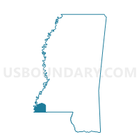
Outline

Summary
| Unique Area Identifier | 606935 |
| Name | Longmire Precinct |
| County | Wilkinson County |
| State | Mississippi |
| Area (square miles) | 106.34 |
| Land Area (square miles) | 105.83 |
| Water Area (square miles) | 0.51 |
| % of Land Area | 99.52 |
| % of Water Area | 0.48 |
| Latitude of the Internal Point | 31.28153250 |
| Longtitude of the Internal Point | -91.17222880 |
Maps


Graphs
Select a template below for downloading or customizing gragh for Longmire Precinct, Wilkinson County, Mississippi


Neighbors
Neighoring Voting District (by Name) Neighboring Voting District on the Map
- Centreville Third District Precinct, Wilkinson County, MS
- Cold Springs Precinct, Wilkinson County, MS
- Crosby Voting District, Amite County, MS
- Gloster Voting District, Amite County, MS
- Knoxville Voting District, Franklin County, MS
- Palestine Voting District, Adams County, MS
- Woodville Fifth District Precinct, Wilkinson County, MS
Top 10 Neighboring County Subdivision (by Population) Neighboring County Subdivision on the Map
- District 3, Adams County, MS (6,061)
- District 5, Wilkinson County, MS (2,521)
- District 3, Amite County, MS (1,971)
- District 3, Wilkinson County, MS (1,748)
- District 4, Wilkinson County, MS (1,626)
- District 1, Franklin County, MS (1,566)
Top 10 Neighboring Place (by Population) Neighboring Place on the Map
Top 10 Neighboring Unified School District (by Population) Neighboring Unified School District on the Map
- Natchez-Adams School District, MS (32,297)
- Amite County School District, MS (13,131)
- Wilkinson County School District, MS (9,878)
- Franklin County School District, MS (8,118)
Top 10 Neighboring State Legislative District Lower Chamber (by Population) Neighboring State Legislative District Lower Chamber on the Map
Top 10 Neighboring State Legislative District Upper Chamber (by Population) Neighboring State Legislative District Upper Chamber on the Map
Top 10 Neighboring 111th Congressional District (by Population) Neighboring 111th Congressional District on the Map
Top 10 Neighboring Census Tract (by Population) Neighboring Census Tract on the Map
- Census Tract 1, Adams County, MS (7,602)
- Census Tract 9501, Wilkinson County, MS (4,146)
- Census Tract 9502, Amite County, MS (3,632)
- Census Tract 9502, Franklin County, MS (2,725)
Top 10 Neighboring 5-Digit ZIP Code Tabulation Area (by Population) Neighboring 5-Digit ZIP Code Tabulation Area on the Map
- 39120, MS (32,334)
- 39669, MS (6,045)
- 39631, MS (3,732)
- 39638, MS (3,333)
- 39661, MS (2,997)
- 39633, MS (1,094)